
Why we are fighting this proposal
This area of North Hampshire is an ancient and very precious landscape with unique characteristics which is why people have chosen to live in North Hampshire for the natural beauty of the arable fields, woodland, rivers and canals and green corridors that protect wildlife. The proposed development consists of 5 enormous warehouses, 20-30 metres high, that will blight the landscape and ruin the view from all viewing angles. This ancient area of North-East Hampshire will no longer be able to claim to be a rural landscape.
destroying unique evironmental habitats
Whilst the developer downplays the environmental aspect of this site, it is important to realise there are increasingly fewer open areas of land like this in this area and once developed will be destroyed forever. It also borders onto and feeds into extremely sensitive habitats that will be directly threatened. These include;
Several streams and waterways that run through or close to the proposed development. These feed into the nearby River Whitewater which is a very rare and environmentally unique chalk stream – with only about 200 chalk streams left in the world, most of them in southern England which makes them all the more special. The runoff from the acres of concrete used by thousands of dirty diesel lorries and possible warehouse spills directly threatens this unique environment.
The development presents a significant increase in the risk of flooding. This site is already designated to be in Flood Zone 3 on the UK Governments Flood Risk website with ”a high probability of flooding from rivers”. These fields are often covered in large pools after heavy rain. Covering the entire area in concrete will make local flooding even worse.
Removal of 80 acres of good quality agricultural land from food production – currently used to grow potatoes, cereals and a wide range of other crops that contribute to the countries food security.
Destruction of wildlife habitat where currently deer, pheasants, badgers, newts, herons and other species of wildlife graze freely.
TRAFFIC
This development would create an enormous increase in road traffic on all roads leading to the site – the development company states in excess of 12,000 vehicle movements between 7 am and 7pm, seven days a week, with a “significant number” being HGVs:
This level of traffic would impact all roads around North Warnborough, Odiham, Hook, and further afield on routes from the M4 to Junction 5 of the M3, along the A 287 to Farnham, and on the B3349 to Alton and beyond to the A 31 and A32.
It would also necessitate major alterations to Junction 5 – costing at least £100m.
Widening of the A287 dual carriageway to three lanes.
Complete redesign of the roundabout leading to the bypass costing several million pounds.
Increased congestion in surrounding villages if vehicles seek to avoid obstructions at Junction 5.
24-hour site noise and light pollution caused by manoeuvring heavy vehicles.
Parking and fuelling for 200 cars together with a refreshment area - in effect a new motorway service station.
Damage to our national heritage
The site directly borders onto an area listed by Historic England as a scheduled monument containing the remains of a large, late Roman villa, bath house and other outbuildings originally uncovered in the 1930’s. The site has not been examined by archeologists since that time.
It is highly likely given the size of the villa that the immediate area encompassing the planned development space will contain further Roman remains yet to be discovered.
There have been several other nearby excavations in and around North Warnborough that have produced finds indicating a continuous human presence going back to at least the Neolithic period.
This enormous development directly threatens a site that may contain important and significant parts of our heritage that will be completely destroyed if it is allowed to go ahead.
Flood risk map from the Environment Agency showing how part of the proposed development site is in flood zone 3 ”with a high probability of flooding”

This shows the sheer scale of the proposed development within the red border indicating its direct proximity to the River Whitewater and the Roman Villa (shaded in pink).
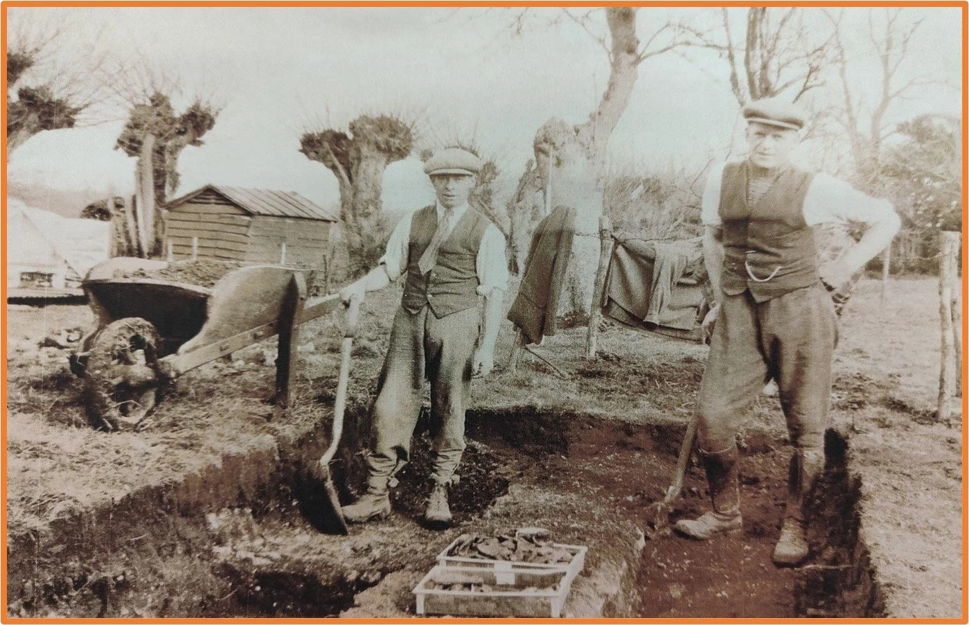
The Roman Villa site at Lodge Farm was last excavated in the 1930’s and can tell us so much more if left alone so that a modern archaeological dig could be organised.
Help us
The developers are purely interested in making money and don’t care about the potential damage this development could do to our local countryside and the environment.
We are fighting hard to prevent this damaging development and there is a great deal you can do to help us. Please click the link below to find out more.

The River Whitewater is one of only 200 precious Chalk Streams left in the world and is directly threatened by this proposed development. Here showing how it regularly bursts its banks to flood nearby fields.
